
If you had visited Holme Fen, part of the Great Fen, a few hundred years ago you would have experienced the largest lake in southern England – Whittlesey Mere. Today however, Holme Fen is a 269ha, biological Site of Special Scientific interest (SSSI), and National Nature Reserve and home to 500 types of fungi, some of the finest silver birch and a wealth of wildlife. It was also one of the richest peatlands in the country.
Fen is a local term for an individual area of marshland or former marshland, characterised by flat, low lying areas supported by a system of drainage channels and man-made rivers (dykes and drains).
It is thought that Whittlesey Mere formed around 500 BC when silt was deposited by the Rivers Nene and Welland and water backed up as it couldn’t freely move towards The Wash. As a result, a series of lagoons were formed and aquatic plants, sedges, reeds and mosses began to grow. As the country experienced wetter and drier periods, the plants decomposed and turned into peat. At its largest extent, the Mere was 6 miles across.
Changing the Landscape
In the name of “progress” and higher land values, a group of local landowners, led by William Wells of Holmewood Hall, worked together on plans to drain the land in return for a share. Not only would Holme Fen become rich for agricultural farming, the surrounding countryside would be at a lesser risk of flooding.
Wells realised that as the land was drained, the peat would act like a squeezed sponge and shrink. In an effort to measure what was happening, a timber post, known as the Holme Fen post was erected in 1848. The base of the post was embedded in the clay, around 6.7 metres below the peat at the ground surface.
The Mere was drained in the early 1850s and throughout the summer of 1852, work proceeded on making the bed of Whittlesey Mere fit for cultivation and as expected, the land quickly started to sink.
When the waters had finally left the Mere, the original post was later replaced by a cast iron column thought to have originated from the ill-fated Crystal Palace in London and this is what stands today. In the first 30 years after the Mere was drained, the ground sank around 9 inches a year, however, as the iron post became more exposed, so did its stability, and steel guys were added in 1957, when a second post was also added.
Holme Fen is regarded as the lowest point in the UK, considered to lie around 2.75 metres below sea level, and 4 metres of the posts are now visible above ground level.
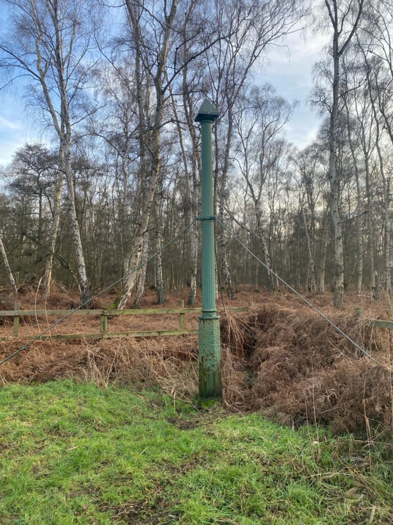
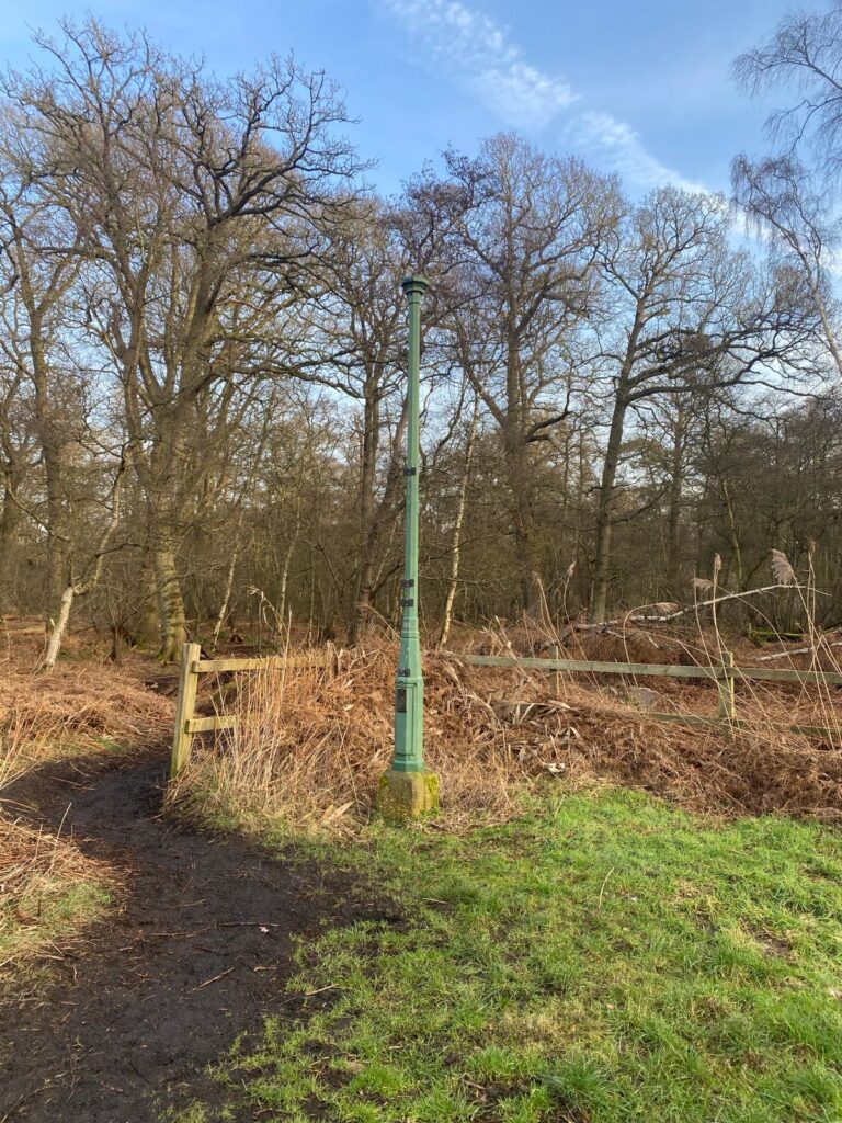
The Holme Fen posts are now 4 metres above the ground. Photos courtesy of Mary & Dave Shiers.
Peat and the environment
Peat is hugely important for the environment as it acts as a carbon store, wildlife habitat and a natural flood control, as it can hold up to 20 times its weight in water.
Peat forms in waterlogged, acidic conditions, when layers of decomposed materials accumulate. The formation of peat is very slow, and can take up to 1,000 years to form just 1 metre. The plants that form peat, capture carbon dioxide from the atmosphere, and as a result, large quantities of carbon become trapped. However, if the peat is drained, it decomposes much faster, releasing the stored carbon and contributing to global warming.
The Great Fen Restoration Project
Draining the Fens has been described as the greatest single ecological catastrophe that ever occurred in England.
The Great Fen is now home to one of the largest restoration projects of its kind in Europe, with multiple pillars of improvement. Wetlands such as this are an underrated but irreplaceable tool for slowing the pace of climate change and protecting communities from storms and flooding. Peatlands cover only 3% of the world’s land surface, but hold 25% of the global soil carbon, making them the world’s most effective terrestrial carbon stores.
A 2017 report for DEFRA by the Centre for Ecology and Hydrology stated that “Conservation managed lowland fens appear to be among the most effective carbon sinks per unit area in England and Wales, whereas lowland peats under intensive arable agriculture in England are probably the UK’s largest land-use derived source of carbon dioxide emissions.“
Each year, a volume equivalent to 1,800 olympic swimming pools of peat is lost due to arable farming, generating over 100,000 tonnes of CO2. By restoring the peatland at the Great Fen, greenhouse gases are being trapped, helping fight the battle against climate change.
Flood protection
As climate change escalates, there will be extreme periods of heavy rainfall, leading to an increased risk of flooding. As the fens are flat and low-lying, flooding is a major concern, not only to the surrounding communities but also to the devastating and costly effects on farmers, so extra flood protection is required.
With climate change projected to cause a 1m sea level rise by 2100 and the almost certain continued sinking of the fens, coupled with many of the flood and water management structures in the Fens coming to end of their design lives, a strategic and long-term approach is needed. Perhaps Dutch-inspired dyke engineering, or will the continued sinking lead to its inevitable decline back to the marshy Meres of times gone by.
There is certainly a fine balance between preserving the peatland and protecting our future and saving the Fens from sea level rise, caused by climate change.
Thinking Ahead on Climate Risk
In total, the Fens are home to around 131,000 households, 13,200 industrial and commercial properties and 185,000 of agricultural land. Climate change represents perhaps the single greatest risk to future property asset values and there are not infinite funds to protect every property.
The simple truth is that some Fenland areas may not give a sufficient economic return to make flood prevention investment worthwhile. And higher flood defences won’t arrest groundwater and dyke flooding. The Environment Agency has already had to cancel or defer significant projects as it seeks to prioritise limited resources. Indeed, there are parts of the east coast that are already being surrendered by managed retreat where the sea encroaches former agricultural land. It is vital that ahead of buying property the risks now and in the future are considered.
Our award winning ClimateIndex™ module aids both purchasers and their legal advisors with the tools they need to understand these risks in greater detail, protecting both their assets and investments.
ClimateIndex™ is available in our popular Avista and Homebuyers residential environmental reports and all of our commercial reports. For more information, call us on 01273 257755 or email [email protected].