

What could be the cause of a recent sinkhole on Seaton beach?
A report of a recent sinkhole on Seaton beach has sparked some local speculation as to whether this collapse could in-fact be related to historical mining activity.
A look at our Geographical Information System (GIS) reveals no records of underground mining in the vicinity of this event.
That said, there are numerous small surface quarries recorded to lie in the local area, these are typically small quarries that were likely used for hedging stone, sea defences or local construction purposes.

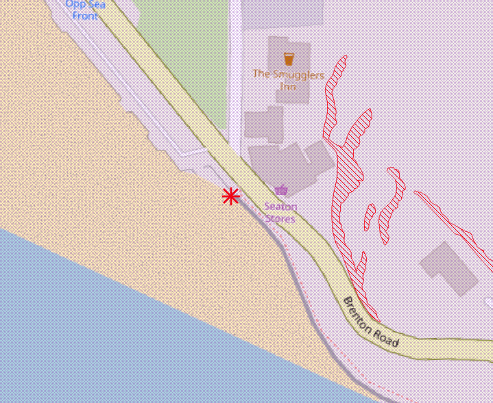
Sinkhole location on Seaton beach – GIS mastermap
BGS data also shows sand and gravel workings on Seaton Beach itself.
In relation to the sinkhole, reports state that flowing water was visible at the bottom of the hole, this suggests a number of possible causes. But one that seems plausible, is that water run off from the steep valley has, over time, washed away finer sediments within the sand. This can create small voids below the surface which eventually lead to a collapse or a sinkhole.
It is reported that investigation works will be carried out, however in the meantime, a cordon has been put in place to help keep the public safe.
Our GeoRisk report includes a comprehensive alert to the likely presence of sinkholes. It covers recent sinkholes incidents in media reports, incidents recorded by the BGS and Peter Brett Associates, and past incidents from Groundsure’s Historical Land Use Database. This dataset contains 75,000 recorded sinkhole incidents – the largest dataset available! Click here to find out more about GeoRisk: https://www.groundsure.com/products/georisk/
Share:
Date:
May 20, 2021
Author:
Tom Harvey-James