

The clue is in the name

The maps plans and charts that the specialists at Mining Searches UK (MSUK) consider for mining risk assessments vary widely and can include written documents, plans and sections of underground workings and surface plans, even plans jotted down back of a cigarette packet style. As a result, the information shown on the plans is viewed on a hierarchical scale with most focus given to the most accurate maps and data that we hold.
The information is derived from a range of providers for example, historical Ordnance Survey plans, British Geological Survey plans, records offices, private collections, or collections bequeathed over the 40 plus years that we have provided our innovative products to our clients in the conveyancing market. We have a great variety and a real mix of sources, but what if any, are the consistencies in the data? Are there ways to cross reference or verify information so that we can interpret the sometimes complex and conflicting data, and arrive at an assessment that provides assurances to our clients.
Here are some common themes:
Openwork – If we see a description of some ancient workings as an openwork this would relate to a former open cut or quarry. If this is associated with a mineralised vein then the openwork could well be an extensive surface cut, linear in nature, following the mineralised vein and extracted to remove the ore. It might tell us that the mineralised vein was rich and productive from the surface. The openwork might be shown on a surface plan for example.
Mine shaft names – The names of the mine shafts will help us to orientate a mine plan. For example, the plans may identify names such as West Shaft or East Shaft suggesting the particular limits of the mine plan. We can also get further clues such as Engine Shaft, which is the main working shaft of the mine. This would suggest that the size of the shaft could be large, in excess of 3.0 metres in diameter. As a result the zone of influence of the shaft may well cover a large area and potentially affect multiple properties. Conversely a shaft might be named Adit Shaft: no more than a metre in diameter, (usually these are excavated for ventilation and to enable clearance and free flowing of mine drainage water). Footway shafts were also usually small access shafts down into the workings with a ladderway. Of course we have the mine shaft names representing the mine owners themselves, or eminent surveyors or engineers that worked in the mines. The team of geologists here at MSUK have located and secured thousands of mining features. This is of great benefit to conveyancers and property lawyers as it means that we can pass properties without the need for further action, safe in the knowledge that the ground conditions have been properly assessed, quite literally no stone is unturned!
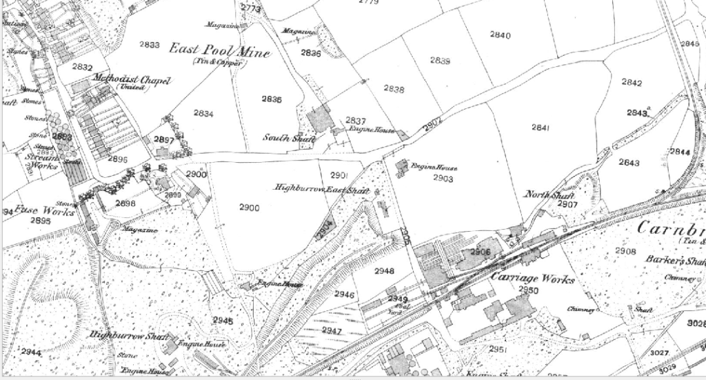
Mineralised vein or lode names – There is a plethora of names of mineralised veins that miners exploited, but once again they have some conformity in terms of orientation or geographical relationship to each other. For example it is no surprise to imagine that a mineralised vein named North Lode is likely to follow an orientation in the northern part of the mine. Great Lode may well be the most profitable vein in a mine. Ale and Cakes Lode provide a great image in the mind and may well have been so called as it was where the miners stopped to take their lunch.
Drainage tunnel or adit names – Once again we see the name provide a clue for what it is. For example, County Adit which was a system of interconnecting drainage tunnels draining numerous mines down in the county of Cornwall. Deep adit, which gave an indication of relative depth and for metal mines in Cornwall and elsewhere across the UK, a measure from which the underground mine levels were measured in relation to. Shallow Adit may be so called as in relative terms the drainage tunnel was shallower than the deep adit. It therefore was not necessarily the case that it followed that shallow adit which was close to the surface.
So overall these brief descriptions give the assessor clues to help interpret the mine workings. A note of caution, as mines were often bought and re-worked, mine shafts were re-named, mines could also be expanded laterally and so an East Shaft may not finally end up being in the far eastern outskirts of a mine. I have also been careful not to overstep the mark as the ancient miners could have had a questionable sense of humour and would name shafts that simply cannot be repeated here.
With time comes knowledge, reliability and skill enabling our team at Mining Searches UK to provide deeper mining insight into the historic mining legacy issues in the UK. Since the acquisition of MSUK by Groundsure, earlier this year, our clients benefit from the unique position of being the only combined environmental and mining specialist providers of search reports in the market. One of the results of this unique collaboration is the really quite brilliant GeoRisk report which provides a most in-depth analysis and advisory on mining and ground stability.
Share:
Date:
Oct 27, 2020
Author:
Paul Raglan