
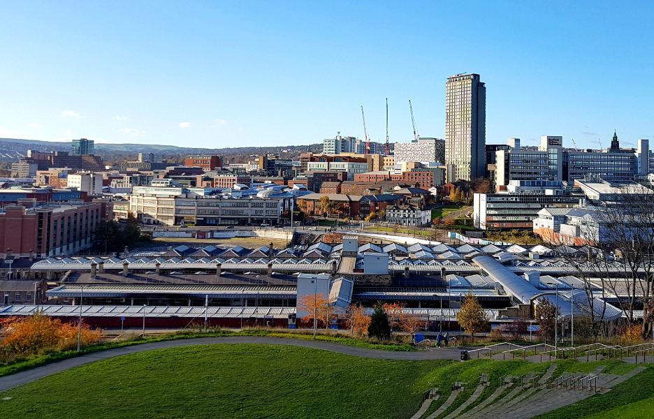
Sheffield’s unique geography, located over seven hills and watered by five rivers, along with its underlying geology of sandstone, shale and coal beds was the key to its furious expansion during the industrial revolution.
For a time during the mid 1800’s, Sheffield became the steel centre of the world. This was, in part, powered by the abundance of the Carboniferous coal beds underlying the region. Many may be familiar with the former coal mines or collieries across the city and local area. However, just as crucial during the industrial revolutions, but much less well known are the numerous clay and brick pits affecting the city.
During the early 1800’s we see the areas of Attercliffe and Little Attercliffe become the centres of much of the steel production. Often neighbouring the steel works or within the immediate surrounding area are clay pits or brick works.
These pits grew alongside the expansion of steel production. By 1851 there were 14 brick pits around Sheffield, growing to 32 in 1893. These were on the edge of the town, but as it expanded they were overrun, and new workings started further out. Critical in steel production were the clay crucibles used to smelt the steel. Local sources of clay were exploited for use in the steel industry.
The area also saw the mining of fireclay essential to making the crucibles to forge the steel, ganister (a hard, fine-grained sandstone) used in the production of the bricks to line the furnaces, along with clay extracted for bricks production for local construction. As we have highlighted in previous case studies, the process of brickmaking relied heavily on finding a source of clay, as well as water and transport routes. With canals in abundance, both water and transport requirements were easily met.
These quarries can be found through the city, some smaller operations and some significantly larger. However, over time many of these quarries were simply infilled, forgotten and built over. One such example can be seen marked on an 1893 OS Map around Darnall Road. Old clay pits are mapped north of Darnall Steel Works, and west of Attercliffe Steel Works.
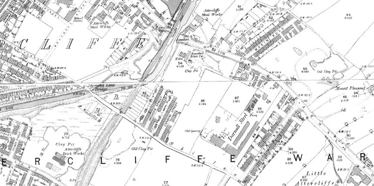
1893 Ordnance Survey map showing Darnall Steel Works, Sheffield
There was also an aqueduct brickyard with its associated clay pit further to the south west. If we were to take into consideration what these areas look like today, it helps paint a picture of how the area has been developed and also outlines some of the potential risks faced by modern urban development. In the case of the Aqueduct Brickyard, the site has been repurposed into a modern commercial complex, including a variety of industries ranging from financial services to a gym and electrical trade supply store.
Whilst lots of the surrounding area remains commercial, there are terraces of residential housing visible on mapping from 1893 scattered around the former industrial land. In some cases, these terraces have since been demolished such as those along Ardmore Street to the south of the Aqueduct Brickyard. Buildings here begin disappearing from the Ordnance Survey mapping from the 1970s and that street remains desolate to this very day.
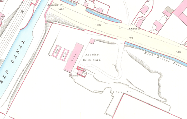
Detailed Historic map showing brick yard and associated kilns
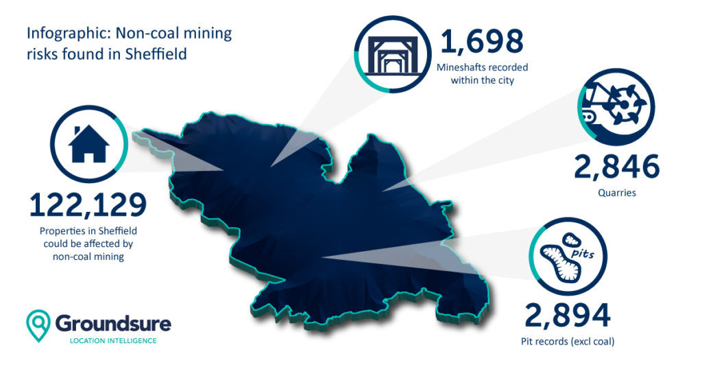
The Darnall Road area is a good example of the patchwork of shallow mined resources that aren’t coal-related across the city council area. Around 122,000 properties, some 35% of the total number in the Sheffield City Council area, could be affected by former non-coal mining activity, such as the former clay pits at Darnall. The infographic below highlights the number of features from our datasets.
This data forms part of an analysis we undertook of major cities in England and Wales on the hidden hazard of mining that isn’t coal-related – download the white paper here.
While most coal mines are the responsibility of the Coal Authority, no such regulations apply to the numerous pits and quarries relating to mining minerals other than coal. This is why it is so crucial to ensure the correct professional reports, searches and assessment have been carried out on behalf of your client.
Our Avista environmental reports provide the most comprehensive view of past mining activity from both coal with a fully inclusive CON29M, together with reporting on more than 60 other minerals, including clay, which are not covered in a traditional coal mining search.
The report extract below clearly shows the past mining and industrial activity in the area which now plays host to a variety of commercial enterprises.
In addition to contaminated land, planning and infrastructure searches (essential for rapidly changing urban areas), Avista also looks into the future thanks to our unique ClimateIndex™ analysis module. This looks at the potential forward impact of climate change on a property-specific basis for a 1-, 5- and 30-year period. This helps your client understand the risks from flooding, subsidence and coastal erosion now, for a typical mortgage term and for within most resale periods.
Former mine workings could make themselves increasingly known as our climate continues to change. Conveyancers are used to ordering CON29M searches for coal mining areas but they do so not necessarily thinking about climate change. These tunnels are often very deep and established, whereas many of the other resources like clay pits can be very informal and worked close to the surface, with often loose spoil just filling in the extracted area.
Our ClimateIndex™ modelling predicts that subsidence could accelerate 8-fold from its current levels in the next 30-50 years. This could undermine shallower workings and pits that were covered over by looser, more informal fill material.
ClimateIndex™ enables your practice to be compliance-ready with future changes to guidance on advising clients about climate change from lenders and legal associations. It also helps your client walk into the transaction with their eyes open as to what the future could hold for their home or asset, as well as any potential impacts on insurance or mortgage availability.
For more information about Avista, past mining risks and the ClimateIndex™ module, contact us on 01273 257 755 or email us at [email protected]
References
Mining & Quarrying in the Porter Valley” by Peter Kennett
“A Short History of Sheffield” (PDF). Sheffield City Council. Sheffield City Council. Retrieved 20 August 2019.
‘Photographs Relating to Sheffield’, Vol. 4, page 16, by C.H. Lea, Cat. No. 914.274 SQ