

Fire Insurance Plans – the future of historical mapping
Groundsure is proud to announce the recent launch of Fire Insurance Plans, which feature detailed plans created by Charles E. Goad available in a Groundsure report for the first time.
To some people, the designs created by Charles E. Goad are pretty pictures of high detailed hand drawn maps with pink and blue buildings used only to decorate a wall.
But to those in the know, these maps are a wealth of useful information. Are these maps just interesting relics or is there still a modern day use for these historical maps – with Fire Insurance Plans you will see just how useful they can be. To fully understand them, we have to look back at to how and why these maps were created in the first place.
History
During the 1800s the industrial revolution swept through the urban areas of Britain. As industry grew, so did the density of buildings, combining dangerous industrial activities with ageing buildings. The risk of fire became an ever more pertinent problem for commercial interests, and the need for urban mapping to assess these risks increased.
In 1885 Charles E. Goad arrived back in the UK having started his company, Charles. E. Goad Ltd in Canada producing fire insurance plans. By 1887 the company had produced the first of his Goad maps in the UK, covering parts of London, Bristol and Glasgow. The company continued to produce the maps throughout the 1900s, with the final maps being produced in the 1970s. Although not the first company to produce fire insurance maps in the UK, Charles. E Goad was the largest. But what made these fire insurance plans are different from other maps produced around the same time?

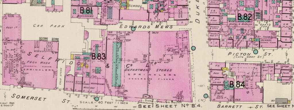
What do Fire Insurance Plans tell us?
The maps produced by Charles. E. Goad Ltd were specifically used by insurance companies to assess the risks of fire to commercial properties. As such these maps contain many features of urban areas, which are not shown on traditional Ordnance Survey maps. Each building is colour coded to show the construction materials used, giving these maps a beautiful and unique pink and blue patterning.
Each building comes complete with its use, height, and the number of windows. On the streets there are details of the nearest fire hydrants, and fire stations are shown along with street widths.
It is the details about individual buildings, that aren’t present on other maps that make these plans of great relevance today.

Are Fire Insurance Maps still relevant today?
From an environmental perspective these maps provide a detailed insight as to the historical land use of each building. Each building contains details of the contents inside that might pose a fire risk including chemicals, kilns and ovens. This information can help guide modern users on historical contaminated land.
Despite some of the maps being around 130 years old, many of the buildings represented are still present and a lot of information provided still rings true. However in a lot of areas the streets have changed dramatically, especially around the 1940s where big changes can be seen before and after the London Blitz.
Despite having been first produced in the UK over 130 years ago these maps have had a lasting impact and similar maps are still being produced today for the same purpose.

Conclusion
These beautiful maps are definitely more than a work of art to hang on your living room wall and those that choose to explore them in depth will be amazed by their detail and what they can tell us about our streets today.
Our new report is an indispensable resource when analysing past land use and historic contamination risks.
So why buy Groundsure’s Fire Insurance Plans report?
- Full OS Mastermap site plan included, and any gaps in the historical maps filled with contemporary Groundsure mapping, provides a clearer impression of the whole site
- Uniquely seamless stitched imagery (of a similar age) for straightforward interpretation and clarity, saving you time
- Dynamic scale making more comprehensive maps much easier to read
See the past more clearly with Fire Insurance Plans from Groundsure. Find out more today.
Share:
Date:
Jul 7, 2017
Author:
Mike Harris