
In Cornwall it can be easy to forget the impact of Cornwall’s rich mining heritage. Gone are the hay days of mining and now we are left with the remnants of an industry that once was. With engine houses dotted across the Cornish landscape some would think it hard to miss any mining features across Cornwall. However, these engine houses we see beautifully doting the landscapes of Cornwall are just the tip of the iceberg.
Many of these mining features have been covered or poorly backfilled by farming, development and landscaping over the years or have collapsed and are no longer visible, yet are still an ongoing risk to new developments. It was not until 1872 that it became a requirement for mines to produce an abandonment plan. This means that while some of the mining is well recorded there are a large number of unrecorded mining features across the county. Site investigations target recorded mining risk while being vigilant for unrecorded workings that may pose a threat to new developments.
Tuckingmill Site
The site is a large housing development which is located on land to the west of South Crofty, in the central mining district of Cornwall. Based on the documentary evidence this is the former Dolcoath Mine which has potential surface and subsurface mine workings within the site boundary. This mine was worked from the 1720s to the 1920s and produced large quantities of tin and copper over its lifetime.
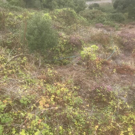
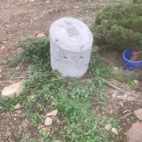
As with many mines, following abandonment, equipment was auctioned off, buildings demolished, and shafts backfilled or capped over. Land often returned to farmland, and as generations passed, all evidence of mining was lost. In the case of Tuckingmill, the only remaining visible mining feature was an open shaft located near the eastern boundary of the southern site (Figure 1) and a cap installed by Kerrier District Council over a known shaft in the southeast of the site (Figure 2).
Fast forward 100 years, the land appears a tranquil, green, undeveloped field, perfect for a proposed new housing development in the Camborne and Redruth area. The developers quickly realised that the historical mining on the site would need consideration and we completed a desktop mining search to reveal the facts under the ground.
According to our records, multiple adits/drainage tunnels, lodes (both at the surface and unknown elevations) and shafts were recorded throughout the site. Following the results of the desktop study and information from previous site works, an initial targeted investigation of the highest risk areas of the site was carried out to guide the client in the design and development of the site, including potential costs for remedial works to mitigate the mining risk.
Ground Investigation
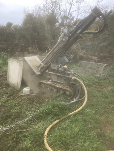
We undertook a 50 day mining drilling investigation on the 8 hectare site to delineate the potential mining features. Using a Holman Minirig (percussive, rotary open hole drilling) (Figure 3) to target the zones Groundsure had deemed to be at high risk of mining. During this investigation, numerous mining features were observed, including shafts, stopes (lode workings), exploratory pits, quarries and tunnels.
Percussive open hole drilling is a widely used technique to identify surface and near surface mining features, areas of voids or suspect soft, natural or man-made ground conditions. Natural ground horizons are confirmed by assessing the fine dust and chippings returned by the compressed air flush, and monitoring the drill rate and constant hammer action. Backfilled or voided ground (mine workings) is identified by the loss of the air flushed returns, increased drilled rate and the hammer action becoming intermittent or absent.
During investigations, we targeted the areas of concern identified in our search report, initially by using controlled spacing of boreholes across the risk areas, and then where potential mining features were found, we completed further drilling of various angles to assist in interpreting the mine workings.
Assessing the Lie of the Land
We determined the shape, depth and direction (geometries) of possible features using multiple section lines across the site, until they were accurately mapped on the site. General coverage of the site, away from the high risk areas identified in the Search, was undertaken with shallower long boreholes to gather information on the ground conditions across the site and to intersect any unrecorded mining features away from the main risk zones.
Both known and unrecorded mining features can be a major cause of unplanned/abnormal costs in a development. It causes delays to development as the site is investigated and remediated or where designs have to be adapted to reflect the newly encountered geotechnical characteristics. Addressing the mining risk at the earliest opportunity, and employing a robust site investigation will allow for any design and remedial works to be built into the planning and costs for the development, improving the safety and financial performance of the project.
For Tuckingmill, we anticipate that further investigation and remedial works will be required for any mine workings previously identified. As a final precaution following these remedial works foundations for new buildings will be inspected for any signs of unrecorded mine workings. All services which can be provided by us throughout the various stages of site development.
Access our Mining Assessment One Stop Shop
Residual mining risk in Cornwall is present from both recorded and unrecorded mining features. An early assessment of the risk by means of desk studies and site investigations are key in keeping developments running to schedule while minimising unforeseen costs to the developer.
The site provides a good example of the breadth of our one stop shop service – desktop reports, expert analysis by geologists backed by a huge records archive, together with ground investigation and remediation support for development sites, residential and commercial property.
Find out more about our range of mining services here.