

The Benefits of the Screening Report
The Groundsure Screening Search report provides an overview of the environmental risks relating to commercial properties, high value residential properties and those with more than five hectares of land.
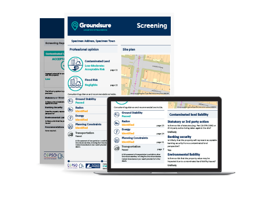
The Groundsure Screening Search report includes detailed environmental data on contaminated land, flood risk, ground stability and geological hazards. The data is reviewed and a professional opinion provided by our Environmental consultancy team. The report makes use of our unique historical land use database, which features detailed and specific land use information dating back to the 1840s, and includes datasets from the Environment Agency and the British Geological Survey.
The report has been developed in conjunction with leading UK banks and meets lending-security compliance, whilst addressing obligations under the Law Society’s Practice Note on contaminated land.
Why buy the Groundsure Screening Search report?
- Lowest further reassessment in the market
- Utilises Groundsure’s high quality historic mapping
- Accepted by ALL major UK lenders.
- Backed by £10 million Professional Indemnity Insurance
- 24-hour reporting time
- Data is reviewed and opinion provided by specialists within Groundsure’s consultancy team
- Consultants are available to answer questions about the findings within the report
- Environmental insurance available if required.
The Groundsure Screening Search report is designed for ease of use and provides a single page executive summary covering key findings, recommendations and guidance.
Covered in the report:
- Historical land use database of potentially contaminative features including garages, petrol sites, tanks, energy installations and military/ordnance sites – the only report on the market to include this level of detail
- Up-to-date environmental permit, incidents and registers data
- Detailed active and historical landfill data from authoritative sources, including the Environment Agency, British Geological Survey (BGS), Local Authorities and historical Ordnance Survey mapping
- Underground electricity cables and gas transmission pipelines
- Geology, hydrology and hydrogeology
- Designated environmentally sensitive sites including Green Belt, Local Nature Reserves and National Parks
- Ground stability assessment including non-coal mining and subsidence risks
- Coal mining screening
- Flood risk screening uses Environment Agency and BGS data
- Additional information covering overhead powerlines and existing and proposed mobile phone
Share:
Date:
Jul 11, 2016
Author:
Catherine Shiers