London is perhaps the best example of where a landscape has been built over for millennia, but would you associate chalk mining as a potential risk to London Property?
As our capital grew, it concealed many stories of its past, chalk mining being one of them.
It is easy to look at the web of neighbourhoods and centres merged one into another and forget the industries that took place in once rural fields and villages. It is even more likely that chalk mining would be the last thing that anyone may associate with the city.
When an area has been subject to intense redevelopment and mass urbanisation, any evidence of former chalk mining activity is likely to have been lost, especially if it has been built over. This makes it harder for people to connect with this history and therefore, the potential risks it may pose.
The capital sits on the London Basin, a geological feature made up of a wide variety of different rock types but split into 3 main formations or groups. The top layer is London Clay, famed for creating the yellow stock bricks, with their unique hue which adorn some of the city’s most ornate buildings. These clays overlie the Lambeth Group which itself sits above rich deposits of chalk.
As London grew, along with its industrialisation, so did the demand for lime mortar, bricks and tiles for buildings. To feed this development frenzy, multiple informal chalk mining operations opened up to extract the precious mineral that lay beneath and on the edge of the city, often with associated brick works.
In the scramble for resources, there was no regulation on how chalk mines were dug and crucially, very few records of how they were left abandoned, once exhausted. Plans that do survive from the late 18th, early 19th Centuries, are often far from perfect, both in terms of preservation and of detail and accuracy.
Chalk Mining and Closed Classrooms
Pinner is the very epitome of inter-war metropolitan expansion, fueled by the expansion of the metropolitan line of the tube network. Leafy, wide suburban avenues lined with art deco-inspired houses behind picket fences convey a sense of tranquility and order. An unlikely area therefore for chalk mining? When you lift the lid on the ground beneath, it also plays host to a vast thick chalk deposit which was heavily exploited during the 19th Century and likely far earlier back in time too.
It sits well away from the deep clay deposits, which means that chalk was very close to the surface. Miners therefore had a lot less trouble digging down to reach it and all around this shallowest perimeter, multiple informal chalk mines were opened. One well documented mine, Dingles, was owned by a local brick maker and chalk was taken and added to clays and sands to stop the finished products cracking. It proved popular with miners as it included veins of Hertfordshire Puddingstone, a conglomerate rock including flint which meant the shafts felt more robust when they were being used for extraction.
Much of the excavated area is now built over, with part of the shaft system currently underneath a sports field, allotments and Dingles Wood. The chalk has been worked by a variety of methods, from primitive, isolated and sporadic chalkwells to extensive subsurface tunneling and the creation of multiple underground galleries – very few of which were known about until it was too late.

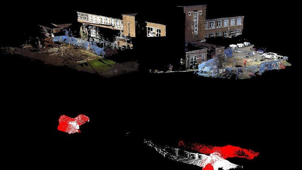
Chalk mine under Pinner school. Image courtesy of Harrow council.
It is the galleries that have caused well-documented property damage. In 2017, one of these shafts collapsed within the grounds of Pinner Wood School, forcing it to be evacuated while detailed investigations were launched into the cause of the collapse. Laser imaging of the previously uncharted and unknown tunnels revealed that they stretched beneath the school buildings and that mine roofs had collapsed in certain places. The school was declared unsafe and it was nine months before pupils and staff could return to the classrooms once the tunnels had been professionally in-filled.
Subsiding South of the River
Very similar geological conditions to Pinner exist south east of the River Thames. While they contrast in terms of look and feel today, Plumstead, Blackheath and Chislehurst all sit on the edge of a huge chalk outcrop beneath surface gravels. There is quite a marked difference to the pattern of urban development though compared to Pinner, with many closely built housing terraces and estates now proving very popular as new crossrail, overground and DLR lines have connected the area to the City.
Some mines were well documented – such as those close to Blackheath, which had been extensively quarried for centuries. Four main chambers run at a depth of 32ft down below the surface. The main cavern is beneath The Point, at the edge of Blackheath, about 170ft below the surface.
The caves were used as a hiding place from invading Danes in the 5th Century and a base for republican warriors, the Levellers. It was also used in 1853 as a ballroom for a masked ball and incredibly, the chandeliers were still there when the caves were reopened in 1938 to be considered for use as an air raid shelter. But the area has also been extensively regenerated and built upon, with substantial blocks of flats as gentrification took hold around Deptford.
But what of the unrecorded or forgotten shallow chalk mine workings? It was just a question of when. In 2016 the question was answered, following a collapse outside two newly constructed properties at Brickfield Cottages in Plumstead. Neighbouring properties within the development were duly evacuated due to the area being deemed unsafe.
The incident hit the local press with locals angry and confused as to how this could have been allowed to happen, given the properties were so recently built on a plot previously occupied by a soft drinks company. In an area with a known history of extensive mining and quarrying, surely the developer would have accounted for the potential risk from historic mining activity and the possibility of ground subsidence as part of their site appraisal?
Mapping Reveals the Clues behind the Name


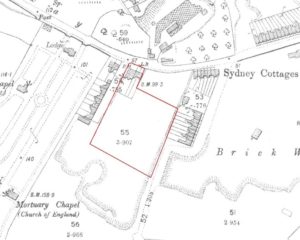
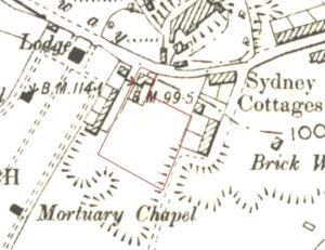
1888 map showing brick works. 1897 map showing more defined workings.

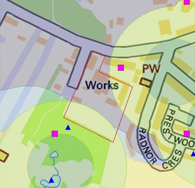
Recent map extract showing Groundsure Hazards
data and former drinks factory works.
The clue is, of course, in the name of the development, but looking at the nearby historical mining data, you can see the area has been heavily worked for a variety of rock types and especially for brick production. Brick fields were common in the 18th and 19th Centuries and typically any topsoil was removed by hand, which helped to expose the much sought after clay deposits found below. These clays were then extracted and were commonly mixed with chalk to form bricks. Consequently, close to former brick fields, you would also find evidence of chalk mining.
As far back as 1865, the Ordnance Survey records brick works in the area, but little evidence shows actual extraction. However by 1894, it is clear that the works have expanded and our historical maps clearly show signs of quarrying directly upon what would become the development area.
In the 1896 edition, extraction has expanded again, this time further east towards the area that will become known for its large underground chalk mine. This mine lies less than 100 metres east of the development area and has been responsible for a number of settlement and subsidence events taking place. It includes a network of tunnels and galleries as well as a number of shafts sunk down through the topsoil into the chalk below.
Unlike at Pinner Wood School, the issues at Brickfield Cottages arguably could have been avoided. Our own in-house Historic Land Use Data and historical mining archive, along with our vast collection of BGS geological mapping shows quite clearly the potential risk here. Thorough pre-construction investigative works would have been necessary prior to even breaking ground, in an attempt to understand what is really happening in the ground below. All 40 residents in the development, but ten were forced to remain out of the homes for some weeks while the 5 X 5 metre cavities underneath the homes were filled with concrete.
Be Sure Underground
How many more developments on top of these workings have taken place without prior due diligence? With increased climate change, more soluble soil and rocks like chalk and limestone may be more prone to collapse as both locally heavy rainfall or drought-related subsidence from the London Clays and gravels could accelerate the risk.
Our recent white paper has revealed the potential scale of this risk. In excess of 830,000 properties, covering 18% of the Greater London area could be affected by future subsidence from past non-coal mining activity.
To protect your client as part of their conveyancing searches, order an Avista report from Groundsure. Not only do you get ten environmental searches including contaminated land, flooding and natural ground stability, but mining of ALL types including coal AND non-coal minerals like the chalk and clays found in London.
Not only that, you can access our expert mining consultancy team on your client’s specific site, property or development opportunity to see how it could be impacted, or indeed if the risk can be mitigated.
For more information about Avista contact us on 01273 277 755 or email us at info@groundsure.com
keep up to date with Groundsure by following us on Twitter.
References
https://www.bbc.co.uk/news/uk-england-london-39371411
http://londongeopartnership.org.uk/wp/wp-content/uploads/2018/08/GLA36.pdf
https://www.blackheathandgreenwich.com/copy-of-greenwich-palace-and-cromwell

