A combination of high spring tides and Storm Kathleen bringing strong onshore southerly winds, created some unprecedented tidal heights and flooding affecting property across Hampshire, Sussex, the West and North West during the Easter holidays.
The event coincided with significant spring tides, anticipated at this time of the year. However, it was the effect of the storm surge that magnified the height of the tide which caused a series of significant breaches in many shoreline communities.
Some experts and commentators suggested that the total solar eclipse witnessed across North America and tracking across the North Atlantic may have had some part to play too. Total eclipses are where the sun and moon (in its new moon phase) are in perfect alignment and do create a significant tidal bulge from the combined gravitational pull of both, along the track of the visible eclipse.
However, the north west coast of Scotland would only have seen a partial eclipse, so the effect would have been relatively minimal, compared to the low pressure and wind direction brought by the storms.
Record Tides bring the Surge
Record high tides were recorded across Hampshire, Dorset and West Sussex overnight between the 8th and 9th April. This video shows how water overtopped the entrance to Portsmouth harbour, almost completely submerging the well-known seating area outside the famous Still and West Pub, which suffered some water damage.
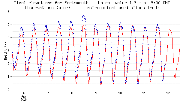
The National Tidal and Sea Level Facility astronomical prediction for the 8th April spring tide would have reached just under 5 metres, but it had been tracking above that in real time in previous days. In fact, overnight on the 8th it was close to 5.75m.

This extra height combined with the waves whipping up over the walls defences caused significant overtopping and flooding of the roads and around the heritage property and businesses in Old Portsmouth.
Record-breaking figures were also measured up the Hamble River, Beaulieu, Woolston and Eling in Hampshire, as well as up the estuaries in Wareham and Weymouth in Dorset.
Impacts along Estuaries
Storm surges, combined with the high spring tide can also magnify estuary and wider river catchment flooding. Ordinarily, these stretches of estuary carry a significant body of water up and down with its twice daily tidal flow. But with an already saturated catchment from the high levels of rainfall over the winter and early spring, rivers are already swollen and when the downstream and upstream flows combine, it can cause real problems.
Overnight on the 8th April and morning of the 9th April, more than 200 people had to be evacuated after the River Adur burst its banks. Residents of Shoreham on Sea were forced to stay awake overnight to put together their own flood defences.
According to BBC reports, resident Gareth Theobald said he rang Adur and Worthing council and was told the council hasn’t “got any provisions to support local residents and businesses in the area” and had “no sandbags“. An Adur District Council spokesperson said the authority does not have the funding to provide local residents and businesses with sandbags and directed them towards guidance on its website.
The spokesperson said the council was working to build a wall to defend properties from an overflowing River Adur during storms but objections had delayed the scheme. The Sussex Yacht Club handed over the land in 2021 to enable The Environment Agency (EA), Adur District Council and West Sussex County Council to commence the project. However, the setbacks have kept the town vulnerable to inundation.
Mr Theobald continued: “I was out the front of the building and watching the water just get higher and higher and higher, and then helping or stopping traffic going into the floodwaters, and then just watching in disbelief as the whole of Brighton Road and our multimillion-pound development was being engulfed by floodwaters.
“The amount of water is scary and unprecedented, and those houses opposite our development are lower-ground flats and they were all flooded under a foot or so of water.”
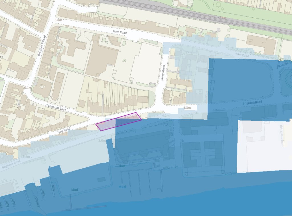
The row of properties that he refers to can be seen in the screen capture from our groundsure.io map viewer below.

The block of flats that Mr Theobald lives in, close to the Yacht Club, are sat fully within Flood Zone 3 (the highest level of flood risk) even when taking into account existing flood defences, using the Risk of Flooding from River or Sea (RoFRaS) data. Beyond, the terrace opposite sits in Flood Zone 2, but the unprecedented level of overtopping meant the lower ground floor flats were directly affected. These residents are sure to be relieved once the Yacht Club defence scheme can finally get underway.
The River Arun is one the fastest flowing rivers in England and is tidal some 25 miles inland from its mouth at Littlehampton. In the same way, the combination of swollen river and tidal surge prompted similar flooding in Littlehampton, forcing the evacuation of homes and businesses in Rope Walk and Ferry Road.
Tony Thompson, the owner of Bridge Garage in Ferry Road, said the flooding was “the worst he had seen in 40 years”, while neighbouring business, SRR Motorsport suffered damage to customers’ cars and are now unsure when they will be able to reopen or obtain any insurance protection.
Defences not enough
Continuing west, a holidaymaker at Medmerry holiday park, near Bracklesham woke at 0130 AM to find his bed was “rocking and floating on water.” Lee, from South Wales, was one of 180 people evacuated from the park, after the water rose up to 6 feet into his property. He was working at the park at the time and lost his tools, laptops and clothes, while his car was completely submerged.
Interestingly, the local area, which has always been subject to flood risk, was the subject of an extensive project to create a zone of managed retreat and intertidal habitat. A 3km shingle bank was subject to regular breach and its maintenance had proved unviable. Development and flood defence infrastructure in Portsmouth and Southampton had, ironically, caused the local sea level to rise. The scheme created a deliberate breach to allow tidal waters to flood and take pressure off nearby settlements in Selsey and Wittering. However, on this occasion, this could not save the caravan park from inundation.
And existing flood defence investment was no guarantee this time around either. In West Kirby near Liverpool, staff at the Tanskeys Bistro had to be rescued by the RNLI after they became stranded by flood water. The area was meant to be protected following a £20m total investment by the EA to build a 1.15km sea wall, which was opened in May 2023. Originally considered an eyesore by businesses that were affected by its construction, questions are now being asked about whether it was up to the job in the first place.
Understanding Coastal and Estuary flood risk
These recent events tell us once again that climate change will continually reset the bar on risk to property and communities. Flood defences are a vital part of our resistance but are only as good as the situation they face. Our current and future ClimateIndex™ flood insight accounts for the presence of these schemes and when used in relation to flood zones can give an indication of the likely risks that a development or existing property could face and may need to adapt in the coming years.
And properties on river estuaries and in more sparsely populated areas where defences may not be viable are especially exposed. An additional 1m of sea level rise is possible by 2100 and while that seems a long way off, it will start to impact through greater storm surges than the one we have just witnessed this Easter.
For more information on our coastal and river flood risk analysis in our residential and commercial reports and how ClimateIndex™ can help chart future risk for homebuyers and businesses, call us on 01273 257 755 or email us on info@groundsure.com
References
https://www.bbc.co.uk/news/av/uk-england-hampshire-68768216
https://www.bbc.co.uk/news/live/uk-england-68766942
https://www.itv.com/news/granada/2024-04-09/cafe-workers-rescued-by-rnli-after-storm-causes-flooding
https://www.theargus.co.uk/news/24247381.littlehampton-flooding-rope-walk-homes-ruined-river-adur-water/
https://www.bbc.co.uk/news/uk-england-merseyside-64961539

