
Definition and classification of Groundwater abstraction and Source Protection Zones
Groundwater provides a third of our drinking water in England and Wales, 7% in Northern Ireland and 3% in Scotland [1].
In some areas of Southern England, groundwater supplies up to 80% of potable water. Potable water, also known as drinking water, is water that is safe for drinking and food preparation. [14] It is crucial that we protect groundwater abstracted for human consumption from pollution and ensure that our water is completely safe to drink. [2], [3] To this end, the Environment Agency [EA] designates Source Protection Zones [SPZs] around these groundwater supplies. SPZs, together with the application of policies for preventing the pollution within them, are the keystone for the protection of these sources. [3], [4]
Groundwater is water occurring beneath the earth’s surface at depths where pore spaces in soil, fractures and voids in rocks are completely saturated with water. The depth at which soil pore spaces or cracks in rocks become completely filled with water is called a saturated zone or a water table. [15] Groundwater supplies are recharged by snow or rain that falls on the earth’s surface, infiltrates through the soil, and seeps down in to the cracks to become groundwater. It will eventually come back to the surface discharging to streams, springs, rivers and lakes. [10]
Groundwater contained in aquifers is one of the most significant sources of drinking water. [16] An aquifer is defined as a permeable rock that stores groundwater and allows the water to flow into a well or borehole, through the voids or pore spaces. [8] To protect groundwater the EA has identified different types of aquifers including Principal aquifers, Secondary aquifers (further subdivided into Secondary A, Secondary B and Secondary Undifferentiated) and Unproductive Strata. [9] Principal aquifers provide a significant amount of water for drinking; Secondary aquifers provide a small to moderate quantity of drinking water; and Unproductive strata have negligible significance for drinking water supply. [12] Most groundwater used for water supply occurs in permeable rocks such as sands and gravels (e.g. the Lower Greensand), in sandstones (e.g. the Permian Sandstone and the Triassic Sandstone) or the open cavities of limestones (such as the Chalk and the Jurassic limestones). These rocks form the principal groundwater aquifers or reservoirs in the UK and are found in the lowlands of England. [8]

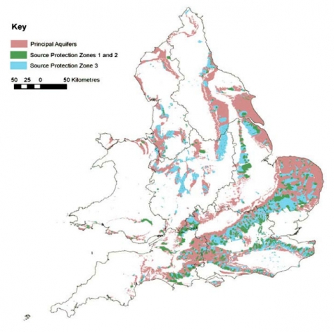
Figure 1: Principal aquifers and source protection zones 1, 2 and 3 in England and Wales. Supplied by EA, 2013.
Source Protection Zones (SPZs) are defined by the EA (for England), Natural Resources Wales (NRW) (for Wales), and the Environment and Heritage Service (for Northern Ireland) for groundwater sources such as wells, boreholes and springs that are used for public drinking water supply. [2], [5] SPZs show the level of risk of contamination from activities on or in the ground that have a potential to cause groundwater pollution in the area and affect water quality at an abstraction. [5] The pollution threat depends on whether the activity is located within the catchment of the groundwater source and on the travel time to the abstraction point. The risk posed by a particular activity to a groundwater source depends on its proximity. Travel time of potential pollutants is defined as an estimation of the time it would take for a pollutant which enters the saturated zone in an aquifer to reach the abstraction point. The Environment Agency has classified groundwater source catchments into three main zones, two of these are defined by the travel time of potential pollutants, and the third is determined by the source catchment area itself. [11]
Source Protection Zones are classified as follows:
Inner Protection zone (Zone 1)
SPZ 1 is the zone closest to the site of the well or borehole showing the area of highest risk. This zone is designed to protect against the effects of human activities which might affect the groundwater source, particularly against microbial pollution. SPZ 1 is defined by a 50 day travel time from any pollution below the water table to the groundwater source and has a minimum radius of 50 metres around the source. The 50 day travel time is based on the time it takes some biological contaminants to decay. [2], [4], [5]
Outer Protection zone (Zone 2)
SPZ 2 is larger than SPZ 1 and is the area defined by a 400 day travel time from any pollution below the water table to the groundwater source. This travel time is the minimum period over which the Environment Agency considers that pollutants need to be diluted, reduced in strength or delayed by the time they reach the source. SPZ 2 is defined as the minimum recharge area required to support 25% of the protected yield and has a minimum radius of 250-500 metres around the groundwater source, depending on the size of the abstraction. [2], [4], [5]
Final Source Catchment Protection zone (Zone 3):
SPZ 3 is defined as the area around a groundwater source within which all groundwater recharge (whether derived from precipitation or surface water) is presumed to be discharged at the abstraction source. This zone largely depends on the volume abstracted and the effective rainfall. It covers the whole of the catchment area of a source based on the area needed to maintain abstraction assuming that all water will eventually reach the abstraction point. For heavily exploited aquifers, SPZ 3 can be defined as the whole aquifer recharge area. A Source Catchment Protection zone is designed to avoid long term degradation of aquifer quality. [2], [4], [5]
Zone of Special interest (Zone 4):
SPZ 4 is defined as a surface water catchment, which drains into the aquifer feeding the groundwater source. This is a special case, for example in areas where local conditions mean that industrial areas and other potentially contaminative sources may have an effect on the source, even though they are outside the normal catchment area. [2], [5]
Inner Zone (Zone 1c), Outer Zone (Zone 2c) and Total Catchment (Zone 3c) are noted for subsurface activity only.
Source Protection Zone policies
Source Protection Zones are not statutory. However, SPZ 1 has been included in statutory guidance as the minimum area under the old Groundwater Directive (80/68/EEC) that is identified for the protection of drinking–water sources and is also recognised as an exclusion zone for certain potentially polluting activities listed in the Environmental Permitting Regulations [EPR]. [3], [6]
The UK has developed an approach to dealing with land contamination issues, built around three principles:
- Through the planning system, by ensuring new development and uses of land are protected from existing contamination.
- Through the contaminated land regime under Part 2A of the Environmental Protection Act 1990 (EPA 1990) by ensuring that existing development and land uses are protected from existing contamination.
- Under Environmental Permitting Regulations by ensuring that no new contamination is created due to industrial and other installations.
Some development and land uses threaten the quality and availability of groundwater. This means that land-use planning policies and procedures play a significant role in the effective groundwater protection. The planning system can play a key role in controlling land use and in promoting sustainable development. SPZs are used to focus pollution prevention activity and influence planning decisions, particularly at the strategic planning scale and in the first stages of planning individual developments. Developments must be appropriate to the sensitivity of the site and planning proposals are required to demonstrate that appropriate mitigation measures have been incorporated to reduce groundwater pollution. [3], [6]
SPZs are defined by the Environment Agency (EA) as primarily risk screening tools for assessing developments with the potential for harming groundwater sources of drinking water. SPZs (in particular SPZ 1) and vulnerability maps* flag to operators, developers and regulators areas where the risks to groundwater are higher than others. They are used as the initial tool in support of the EA’s responses to developers and set restrictions to some types of development that may not be appropriate due to the risk they pose to the water environment. Such development types may be, for example: land uses proposed for power generation, land uses proposed for new combustion plants, composting facilities, incineration plants & intensive pig and poultry operations. [3], [6], [7]
Whilst the EA gives advice to developers and planners on development proposals falling within designated groundwater SPZs, it should be noted that these tools are not in themselves a substitute for a site specific risk assessment. In some cases, SPZs and especially SPZ 1 (which is particularly vulnerable to pollution) represents a guide to the need of further assessment of a scheme. A groundwater risk assessment, for which site-specific data is essential, may be required as a condition of planning with the developers being responsible for providing these data. [3], [6], [7]
Threats to and from sources of groundwater
Like any water source, groundwater can become contaminated in many ways. Groundwater contamination is likely to occur when pollutants such as fertilizers, nutrients, pesticides, faecal bacteria or chemicals (leaking from a landfill or a storage tank) are flushed through the rock into the groundwater and reach the aquifer.
If land owner wants to abstract more than 20 cubic metres of water per day from a surface or groundwater source they would need an abstraction licence from the EA. Abstraction licence holders have a legal responsibility to manage groundwater use, maintain water in good quality, and avoid causing groundwater pollution. When groundwater pollutants are detected, a pollution incident should be reported to the EA, who must subsequently investigate the pollution incidents, track down the pollution to the source and assess its impact on the environment. [13]
Groundwater contamination is one of the biggest environmental risks from fracking. [17] Fracking (short for ‘hydraulic fracturing’) is a method of getting gas or oil from shale rock below the surface of the ground by making large cracks in it through hydraulic pressure, allowing the trapped hydrocarbons to flow out. [18] The Infrastructure Act 2015 (InA 2015) simplifies the procedure for obtaining the right to use underground land 300 metres and below for the purpose of exploiting gas and oil, whilst ensuring that communities benefit and that the UK has a robust regulatory regime. Prior to the Infrastructure Act 2015 receiving Royal Assent, the initial indications were that the government would not allow hydraulic fracturing activities to take place within ‘protected areas’ (i.e. Sites of Special Scientific Interest [SSSIs], Areas of Outstanding Natural Beauty [AONBs], National Parks and ‘protected groundwater source areas’/‘groundwater source protection zones’). [19] The final amendments to the bill before it received Royal Assent stated that the Secretary of State had to define what is meant by ‘protected areas’ and ‘protected groundwater source areas’ and this decision had to be made by 31st July 2015. The Act received Royal Assent on the 12th February 2015 and its provisions came into force on the 12th of April 2015. [19] More information is available in the Infrastructure Act 2015, Sections 43 to 48. On 16th July 2015, the Government laid draft regulations that define the ‘protected areas’ & ‘protected groundwater source areas’ in which fracking will be prohibited. The draft regulations ensure that the process of fracking can only take place below 1200 metres in specified groundwater areas (Source Protection Zones 1), National Parks, Areas of Outstanding Natural Beauty and World Heritage Sites. [19]
SPZs are an important tool in fulfilling our duty to protect and secure water resources. The principal reasons for defining SPZs are to influence planning decisions -particularly at the strategic level – and to promote pollution prevention through environmental permits.
*Vulnerability maps identify where a groundwater resource is at risk from pollution (should a pollution source exist) due to the nature of the soil, unsaturated zone or inherent characteristics of the aquifer. [3]
References
1. The UK Groundwater Forum, n.d. What is groundwater? [Pdf]. Available at: http://www.groundwateruk.org/downloads/what_is_groundwater.pdf [Accessed 11 July 2015].
2. Environment Agency, 2015.Groundwater source protection zones [online]. Available at: http://apps.environment-agency.gov.uk/wiyby/37833.aspx [Accessed 11 July 2015].
3. Environment Agency, 2008. Groundwater protection: Policy and practice (GP3) [online] Bristol: Environment Agency. Available at: http://www.norfolk.gov.uk/view/NCC114695 [Accessed 11 July 2015].
4.Chave P., Howard G., Schijven J., Appleyard S., Fladerer F. and Schimon W., 2006. Protecting Groundwater for Health. London:World Health Organisation.
5. Wirral Metropolitan Borough Council, n.d. Appendix E – Definition of Source Protection Zones and Groundwater Vulnerability Assessments [pdf]. Available at: http://www.wirral.gov.uk/planning/docs/dmzfiles/10730_7.pdf [Accessed 11 July 2015].
6. Environment Agency, 2013. Groundwater protection: Principles and practice (GP3) [pdf] Bristol: Environment Agency. Available at: https://www.gov.uk/government/uploads/system/uploads/attachment_data/file/297347/LIT_7660_9a3742.pdf [Accessed 12 July 2015].
7. Environment Agency, 2012. Guidance for developments requiring planning permission and environmental permits [pdf] Bristol: Environment Agency. Available at: https://www.gov.uk/government/uploads/system/uploads/attachment_data/file/297009/LIT_7260_bba627.pdf [Accessed 12 July 2015].
8. The UK Groundwater Forum, n.d. The aquifers of the UK [pdf]. Available at: http://www.groundwateruk.org/downloads/the_aquifers_of_the_uk.pdf [Accessed 30 July 2015].
9. BGS, n.d. Methods and limitations [online]. Available at: http://www.bgs.ac.uk/research/groundwater/shaleGas/aquifersAndShales/methods.html [Accessed 30 July 2015].
10. Unknown, 2015. Groundwater [online]. Available at: https://en.wikipedia.org/wiki/Groundwater [Accessed 7 August 2015].
11. Environment Agency, n.d. Groundwater Source Protection Zones [pdf]. Available at: https://www.gov.uk/government/uploads/system/uploads/attachment_data/file/290723/scho0199betq-e-e.pdf [Accessed 30 July 2015].
12. Environment Agency, 2013. Groundwater protection: Principles and practice (GP3) [image online] Available at: https://www.gov.uk/government/uploads/system/uploads/attachment_data/file/297347/LIT_7660_9a3742.pdf [Accessed 30 July 2015].
13. GOV.UK, 2015. Manage water on land: guidance for land managers [online]. Available at: https://www.gov.uk/guidance/manage-water-on-land-guidance-for-land-managers [Accessed 10 August 2015].
14. Unknown, 2015. Drinking water [online]. Available at: https://en.wikipedia.org/wiki/Drinking_water [Accessed 13 August 2015].
15. The Groundwater Foundation, n.d. What is groundwater? [online]. Available at: http://www.groundwater.org/get-informed/basics/whatis.html [Accessed 13 August 2015].
16. Oskin, B., 2015. Aquifers: Underground Stores of Freshwater [online]. Available at: http://www.livescience.com/39625-aquifers.html [Accessed 13 August 2015].
17. Friends of Earth, 2014.Groundwater and fracking [pdf] Available at:https://www.foe.co.uk/sites/default/files/downloads/groundwater-fracking-75170.pdf [Accessed 13 August 2015].
18. BBC, 2013. What is fracking and why is it controversial? [online]. Available at: http://www.bbc.co.uk/news/uk-14432401 [Accessed 13 August 2015].
19. GOV.UK, 2015. Developing shale oil and gas in the UK [online]. Availablhttps://www.gov.uk/government/publications/about-shale-gas-and-hydraulic-fracturing-fracking/developing-shale-oil-and-gas-in-the-uk [Accessed 13 August 2015].