
We are all aware of the perils of being sucked into clickbait with sensational headlines to drive traffic. But we couldn’t resist one recently from a Midlands regional news portal that carried the headline “Green light for homes on England’s most contaminated site”. We had to check out the location and understand not only what could lead to this eye-catching claim, but also what challenges this could present to the developer.
The headline came from an Amber Valley Council meeting where an outline planning application had been submitted for 250 homes at the Amber Valley Rugby Club.
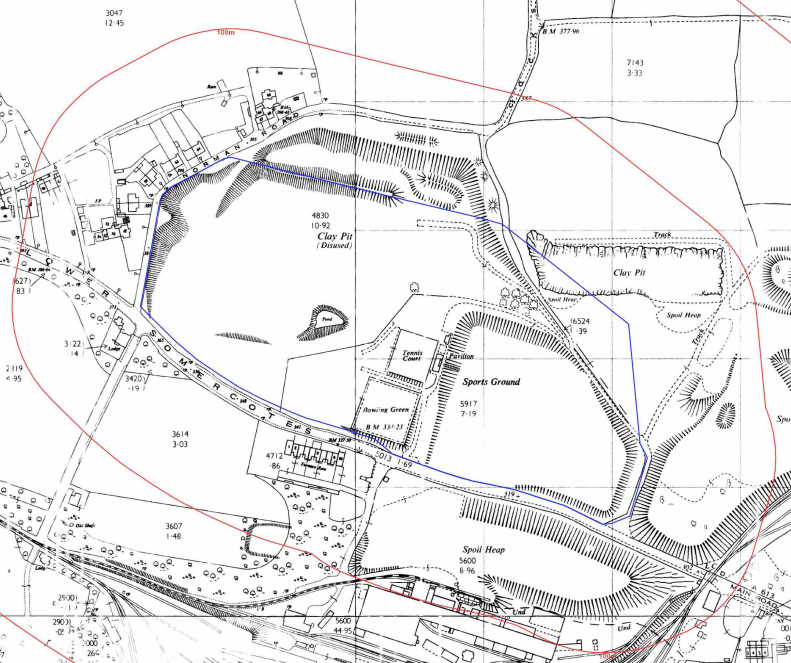
The club is located on the eastern edge of Lower Somercotes, a small mining village expanding with the flourishing coal industry of the 19th century. A village once surrounded by five pits and near to the ironworks of Alfreton. The site itself was a field and then allotments before Cambro Contractors Ltd obtained planning permission in 1948 to extract clay and then coal. Our mapping shows the expansion of the extraction from clay extraction in 1961.

1: 2500 OS mapping – Crown copyright and database rights 2022. Ordnance Survey licence 100035207
This then opened up to a far wider opencast working, which continued extraction until 1978.

1:10,000 – Crown copyright and database rights 2022. Ordnance Survey licence 100035207
It is the story of what happened next that has resulted in concerns about the site’s land quality. It provides a good example of how rigorous research and assessment needs to underpin planning decisions as sites may not be as contaminated as they first seem. At a time when we need housing and the preference is to develop brownfield rather than take greenfield land this kind of assessment can open up opportunities.
A History of Multiple Waste Deposits
Cambro Contractors Ltd was at the forefront of the new landfill licensing, obtaining some of the first waste disposal licences bought in by the Control of Pollution Act (CoPA) in 1974. These were in the form of two licences. One called LS41 on the development site for broadly non hazardous waste including industrial non hazardous waste, construction industry waste, scrap rubber including tyres but specifically excluding anything that at the time was considered contaminative. The Environment Agency records show that the site was only briefly operational for approximately 6-12 months with the licence finally being surrendered in 1980.
To the north of the development site LS01 Cambro was licensed to take a wider range of industrial waste streams between 1973 and 1980. Wastes included inert, industrial and special wastes as well as liquid sludge.
Local recollections of the sites in operations included a special waste cell included in the base of the excavation, cow carcasses, and dioxin from the Bolsover Coalite explosion of 1968. This was an event that continued to be of concern in following years, including a mention in Hansard in 1980.
Redevelopment: Unlocking the Ground Investigations
Armed with this information and information from site investigations an outline planning for 200 houses was submitted in 2014. This proceeded through the planning process but was refused 2 years later by the Planning Inspectorate because the characterisation of the ground conditions was not sufficiently complete to form the basis of the decision.
Since then, further reviews have been carried out on the available data by LQM in 2016 and GVR Geoservices Ltd in 2021. The GVR Services report is particularly clear in presenting the uncertainties and methods to bring them to a resolution. Key areas considered are:
- Sufficiency of the ground investigation works to date
- The potential for radioactive demolition wastes from the Coalite factory explosion
- Sufficient gas and vapour risk characterisation
- Risk of migration of gas, vapour and other mobile contaminants from the adjoining hazardous waste landfill
- Ground stability assessment as a result of deep mine workings below the former opencast workings and necessary foundation designs.
The analytical approach allowed many of these points to be addressed with the information already gathered. Relying on industry guidance the review concludes that the work was sufficient to generally characterise the site, particularly because the materials encountered were broadly consistent with the excavation being backfilled with natural overburden from coaling activities.
However, the concerns relating to the use of the site for more than its permit was taken seriously and specific investigation used to assess them. One issue was a planning application for a special waste cell 4m below the former coal extraction (some 20+m below the current ground level. A geophysical survey identified an anomaly so further ground investigation was used to characterise the targeted area. The soils arising from this area did not cause concern and the anomaly was attributed to a perched water table.
Dumping of radioactive waste was a serious concern and whilst the timing of the opencasting and the 1968 explosion would suggest that dumping was unlikely specialist radiological assessments of the soil and waters did not identify radioactive isotopes.
Gas can come from a range of sources including rotting waste and from former coal mining. Both of which were considerations at the site. The site was not licenced to take putrescible waste and no quantity was found during the investigations, however, gas may migrate from the adjoining LS01 site to the north.
Given the age of the waste, guidance suggests that the peak emissions would have passed, however, gas is very vulnerable to atmospheric conditions so wells were installed and monitored over a year. The results demonstrate ‘locally elevated carbon dioxide and low to very low concentrations of methane and volatile organic compounds (VOCs) as would be expected’’ for filling consisting mainly of natural overburden. More localised assessment is recommended for the more detailed planning application, particularly in relation to landfill LS01 to the north.
The final concern was stability with mine workings lying beneath the opencast floor. With reference to the parameters given in CIRIA guide C758D (2019) it was calculated that void migration is not a concern, providing piled foundations were socketed into the bedrock of the opencast floor.
The council meeting aroused strong feelings from local residents and parish councillors concerned at the spread of potential contaminants from one part of the site to another. The Council came to the conclusion that there would be a requirement for gas monitoring as part of the planning and remediation conditions. It would be part of a phased assessment process so that findings and chosen outcomes for remediation would be refined based on discovery.
Unlocking Potential
This site shows that expertise in data gathering, combined general and targeted assessment designed to establish the actual risk can unlock potential in even the most unpromising sites. However, this work does come at a price and it does affect the viability of projects. In this instance it was reported that at the November Amber Valley Borough Council meeting it was highlighted that priorities for funding had to be chosen.
One councillor noted: ‘while the developer cannot afford to build affordable homes on the site and to provide any money to support health services, due to the cost of remediation and investigations, they would still be providing £1.4 million to support schools and roads in the area. She detailed that the council’s scientific officer was satisfied with the information provided and that “based on the evidence to date it is unlikely that further investigations will identify the need for extensive remediation that would impact on the viability of the development”.
Unlocking potential is a skill developers will need to support the shared target of 300,000 houses a year to be built, especially as the Government is reiterating its commitment to developing brownfield ahead of greenfield sites in order to protect our environment.
Access our Insight
This is where we can add value in the transaction or land appraisal. Our expert consultants manually review our commercial reports to ensure that your client is fully briefed on the potential contaminative and liability issues that may arise for a site acquisition for development or business premises.
For more information about our commercial environmental search reports, current and historic land use data, and approach to land quality assessment to support, call us on 01273 257 755 or email [email protected]