
In this post Clelia discusses the importance of archaeological heritage and the impact this may have on site or property developments and how Groundsure reports can help you to uncover potential issues.
If you have any questions or comments about this article you can contact the commercial team at [email protected]
Archaeology and development
Archaeological or historic remains give us a valuable insight into our ancestors’ lives. They provide concrete evidence, sometimes the only evidence, of thousands of years of human activity and settlement. This is why protecting and preserving these fascinating artifacts is so important. Every archaeological site or monument destroyed means part of the record of our past is also lost2.
This heritage may be preserved in terms of archaeological remains hidden below ground and serves as the focus for archaeological study1. Unfortunately, much of our archaeological heritage has been accidentally destroyed by human activity often as a result of modern developments1. In order to protect these valuable snapshots into our past, particularly important pieces of our heritage are protected as ‘Scheduled Ancient Monuments’.
What is a Scheduled Ancient Monument?
Scheduling is the main legal protection specifically for archaeological remains, although not all scheduled monuments are ancient3. Scheduling can be applied to archaeological remains and monuments of all dates – from prehistoric burial mounds (such as tumuli) and remains of medieval priories to 20th century collieries3. A scheduled monument is defined as an archaeological site or historic building of national importance that receives legal protection from the state4,13. Scheduled monuments are protected against unauthorised change under the Ancient Monuments and Archaeological Areas Act 19794. Only a small number of archaeological sites are scheduled13; however, the fact that an archaeological site or monument has not yet received specific statutory protection does not diminish its individual archaeological importance, or its national historic significance 2.
What implications can archaeology have on development proposals?
Nationally important archaeological remains, whether scheduled or not, may be affected by development works. Local Authorities are responsible for the protection and recording of these sites, as set out in National Planning Policy Guidance7. Records of Archaeological Sites of Interest may be available at a local level from the Local Authorities and their Archaeological Service. The Archaeological Service looks at a database (the Historic Environment Record) of all presently known sites in their area in addition to historical maps and aerial photographs to work out whether archaeological or historical remains may be present 1, 6, 8. If a planning application is on a site that has possible archaeological importance, the developer may need to carry out an archaeological investigation either as part of the pre-application process, or as part of a condition of planning permission (post-application) 2, 6, 7.
This investigation would include recommendations designed to ensure that any development does not damage or destroy any potential archaeological remains. However, even if archaeological remains are found this does not necessarily mean that the development cannot go ahead, but by conducting the archaeological survey it ensures that any significantly important archeological remains are properly recorded and, if necessary, preserved 2, 6, 7. However, if a development is likely to significantly impact on archaeological remains or historic structures deemed to be of high importance, then the planning archaeologist may recommend to the planning officer that the planning application is refused 6.
Finding out if archaeological remains are present on a development site
Initial consultations with the planning division will provide the developer with some idea of the archaeological sensitivity of the site.
This information enables developers and contractors to identify the existence of archaeological remains that may be affected by their proposals and determines what level of archaeological work is required 6, 7, 8. This work is undertaken by a professional archaeologist, however, the cost of this rests with the developer 6, 8. Dependent upon the proposed work and the nature of the archaeological remains there are a number of techniques, which may be applied to a planning application. These range from a basic level of desk-based assessment via a more comprehensive research to a watching brief (the archaeologist observes and identifies any archaeological remains) and finally an archaeological evaluation (including geophysical survey, boreholes or archaeological trial trenches) 6, 7.
Records of Archaeological Sites of Interest, historic features and archaeological remains can be identified within Groundsure Reports for example our LiDAR (Light Detection and Ranging) report can be useful in many Planning applications including archaeological surveys. The Groundsure Agricultural search includes an assessment of archaeological sites of interest. The Historic England’s National Heritage List is a commercially available national database of protected historic buildings and sites, and these records are also included in some Groundsure reports such as our Planview search . In addition to the above, historical mapping contained within the Map Insight Historical Maps report allows for potential archaeological or historical remains that are not scheduled monuments to be identified.
Examples of potential historic features of significance are presented in the figures below:

Figure 1: The Remains of a Roman Villa complex at Hartlip, Kent.
(1908 OS map, 1:2,500 scale)
Archaeological evidence shows that the area around Hartlip, was occupied by the Romans. Hartlip is a village in the Borough of Swale in Kent and the remains of a large Roman villa complex have been excavated at a site approximately a mile to the south west 9.

Figure 2: Roman archaeological remains at Blaxhall, Suffolk.
(1883 OS map, 1:2,500 scale)
Archaeological evidence shows that Roman urns together with a number of coins dating from the reigns of Edward IV, William III and Anne were uncovered c.1863 near Grove Farm at Blaxhall, Suffolk 10.

Figure 3: The site of the Medieval Village of Hawling, Gloucestershire.
(1976 OS map, 1:1,250 scale)
The earthworks are situated to the north-east of the present village of Hawling, on the north-west and south-east slopes of a small valley draining eastwards towards the River Windrush. This monument is scheduled under the Ancient Monuments and Archaeological Areas Act 1979 as amended, as it appears to the Secretary of State to be of national importance 11.

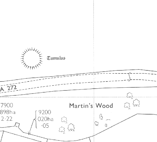
Figure 5: Tumulus is an Archaeological Site in Alton, Hampshire.
(1971 OS map, 1:1,250 scale)
Tumulus is one of the typical monuments of the Bronze Age. Tumuli are widespread across many landscapes in Hampshire, implying a changing role of burial monuments in the Bronze Age 12.
Further advice on the archaeological significance of any site or area, or details of the information required to support a planning application, or meet the requirements of planning conditions, can be obtained from Local authority archaeological advisors and Historic England.
References:
- The London Borough of Merton, 1999. Supplementary Planning Guidance Notes, Archaeology. [pdf] Available at: http://www.merton.gov.uk/environment/planning/planningpolicy/spg.htm [Accessed 25 September 2016].
- The Planning Service, 1999. PPS 6: Planning, Archaeology and the Built Heritage. [pdf] Available at: http://www.planningni.gov.uk/index/policy/planning_statements/pps06-archaeology-built-heritage.pdf [Accessed 25 September 2016].
- East Cambridgeshire District Council, 2016. Ancient Monuments. [online] Available at: http://www.eastcambs.gov.uk/conservation/ancient-monuments [Accessed 25 September 2016].
- Unknown, 2016. Scheduled monument. [online] Available at: https://en.wikipedia.org/wiki/Scheduled_monument [Accessed 25 September 2016].
- Past Perfect, n.d. Scheduled Ancient Monument. [online] Available at: http://www.pastperfect.org.uk/archaeology/sam.html [Accessed 6 October 2016 – link no longer available from referral website]
- East Lothian Council, 2009. Advice Note 2: Archaeology and Development. [online] Available at: http://www.eastlothian.gov.uk/downloads/file/1429/advice_note_2_archaeology_and_development [Accessed 25 September 2016].
- City of York Council, 2016. Archaeological advice about development. [online] Available at: https://www.york.gov.uk/info/20216/archaeology/1307/archaeological_advice_about_development [Accessed 25 September 2016].
- Warwickshire Heritage and Culture, n.d. Planning Archaeology. [online] Available at: http://heritage.warwickshire.gov.uk/archaeology/planning-archaeology/ [Accessed 25 September 2016].
- Unknown, 1999. Hartlip conservation area: character appraisal. [online] Available at: http://www.swale.gov.uk/assets/Planning-Forms-and-Leaflets/Planning-General/Planning-Conservation/Hartlip-conservation-area-character-appraisal.pdf [Accessed 4 October 2016].
- Pictor, S., 2003. Blaxhall’s History between 1700 and 1900. [online] Available at: http://www.blaxhall.com/history/blaxhalls-history-between-1700-and-1900 [Accessed 4 October 2016].
- Historic England, 2016. Medieval and later settlement remains and associated fields at Hawling. [online] Available at: https://historicengland.org.uk/listing/the-list/list-entry/1405912 [Accessed 4 October 2016].
- Hampshire County, 2010. An overview of the Hampshire landscape. [online] Available at: http://www3.hants.gov.uk/an_overview_of_the_hampshire_landscape-2.pdf [Accessed 4 October 2016].